


Haligi | Polar Opposites
The Challenge | Polar Opposites
PolAR
Using AR to change the way we tell stories with our data
A lot of us have seen the numbers, about what global warming is doing to our planet. Most of us may not be able to feel it, but our children will bear the consequences! We've heard people talk about it. Al Gore, Scientists, EVEN THE POPE!!. But we still continue to live, as though it's not a part of our lives.
But in truth, by about about 127 gigatonnes of ice sheet mass in antarctica are affected, causing the sea level to rise around 3.2 mm a year which is around 70 amazon rivers worth of water
Now despite this, why do we seem to turn a blind eye?
We believe that one of the reasons why we barely care is because we can’t see it.
We do not really understand the numbers the scientists show us and its implications to our planet and our lives.
And a lot of times we cant see whats really going to happen until it's too late.
We are a team of dedicated computer scientists and we have a solution, to change the way we tell stories from our data and convey the numbers in a way that is appealing to the public. We are hopeful that this would allow more people to feel the urgency in doing their part in saving our planet from global warming.
NASA can provide all this data, all this important information, all we need to do is to present it in a proper manner so that everyone will be aware of the problem
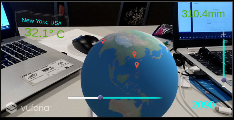
Presenting PolAR, an AR Data Visualization app that can change the way we tell stories about our world data!
PolAR features an augmented reality experience of presenting data about the effects of global warming and the melting of ice caps. Users can see simulations of the rising sea levels,and how countries would be devastated.
For now, we have a limited amount of data to be presented but the potential of AR as a medium for data storytelling is yet to be realized.
We believe that mixed reality can change the way we see our data, allowing for more people to be involved and inspire them to take action and hope for a better earth, for themselves, their children, and mankind.
Github repo:
git@github.com:luis-madrigal/polAR.git
References:
Wiese, D. N., D.-N. Yuan, C. Boening, F. W. Landerer, and M. M. Watkins (2016) JPL GRACE Mascon Ocean, Ice, and Hydrology EquivalentHDR Water Height RL05M.1 CRI Filtered Version 2., Ver. 2., PO.DAAC, CA, USA. Dataset accessed [2018-10-21] at http://dx.doi.org/10.5067/TEMSC-2LCR5.GSFC. 2017. Global Mean Sea Level Trend from Integrated Multi-Mission Ocean Altimeters TOPEX/Poseidon, Jason-1, OSTM/Jason-2 Version 4.2 Ver. 4.2 PO.DAAC, CA, USA. Dataset accessed [2018-10-21] at http://dx.doi.org/10.5067/GMSLM-TJ42.J. Cook, et al, "Consensus on consensus: a synthesis of consensus estimates on human-caused global warming," Environmental Research Letters Vol. 11 No. 4, (13 April 2016); DOI:10.1088/1748-9326/11/4/048002

SpaceApps is a NASA incubator innovation program.