


Voice raisers | The Land Where Displaced People Settle
Awards & Nominations
Voice raisers has received the following awards and nominations. Way to go!
The Challenge | The Land Where Displaced People Settle
People Visualizer
Visualization of Invisible Displaced Population by using Time-series Earth Observation Data and Public Data
- Introduction
Forcibly Displaced people (DP)-related problem has become a humanitarian disaster. As the number of forcibly DP increases, the number of illegal movements is increased exponentially especially in informal sectors. This invisibility leads DP to suffer the consequences of poor working environment as well as lack of basic living facilities. In this line, quantitative analysis and monitoring methods along with the earth observation data can contribute to find hot spots and trace mobility of invisible DP in real-time at a scalable level.
- Problem
However, as data availability is limited only tolegal population in census and other official documents, accessibility of invisible DP-related information tends to be very low. Furthermore, there is no significant methodology for extracting invisible DP and monitoring impacts associated with their movements.
- Objective
We aim to visualize invisible DP by using time-series earth observation data and public data.
- Proposed Methods
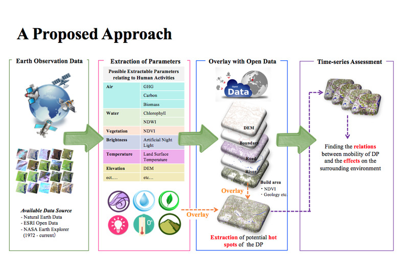
This project targets to detect potential hotspot for the DP by extracting human environmental parameters (e.g. air, water, vegetation, brightness, temperature, and elevation etc.) from earth observation satellite imagery and other available public data, and find the changes by conducting overlayed-time-series analysis.
- Effectiveness
By use of the proposed method, invisible DP can be extracted, and their mobility can be traced and visualized. This further enables to conduct analysis of effects on the surrounding environment of the habitat of DP and strengthen humanitarian support services. Time-series analysis with use of the earth observation satellite data enables us to quantitatively,effectively and efficiently monitor a wider area. Furthermore, the system would contribute to better disaster response and recovery in terms of acquiring the real number of victims and providing necessary support on-time.
- Originality
Application of earth observation satellite data for handing invisible DP problem and improving the humanitarian support systems.
Please find the details from HERE

SpaceApps is a NASA incubator innovation program.