


Save The Hearth | The Land Where Displaced People Settle
Awards & Nominations
Save The Hearth has received the following awards and nominations. Way to go!
The Challenge | The Land Where Displaced People Settle
Save The Hearth
“On average, 26 million people are displaced by disasters every year. That’s one person forced to flee every second.” Save The Hearth provides a solution to monitor the ecosystem of informal settlements and trigger the delivery of humanitarian aids
The observation:
Due to conflicts and natural disasters, an increasing number of families and communities are forced to leave their homes. The majority of of these people are Internally Displaced People (IDP), since they remain inside their country's borders resettling in informal settlements.
The issues :
Lack of information about the settlements:
•Human needs (water, food, wood...)
•Environmental impact
Save The Hearth ❤️:
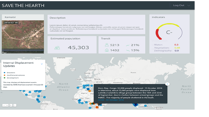
Using NASA satellite datasets, we propose a solution that not only characterize land cover/land use at informal settlements but also help NGOS in risk assesment and prevention.
1. Gather remote sensing imagery collected by NASA satellites and instruments, such as Landsat, MODIS, GRACE, VIIRS related to environmental and climatic conditions (vegetation, wood, groundwater...)
2. Using image processing, track ecological changes in or surrounding informal settlements
3. Calculate ressources & demography Indexes and visualuaze their evolution on our website
4. Using machine learning algorithms, classify settlements according to the level of danger.
Future perspectives:
- Depending on whether it is an urban or rural settlement, the features to consider in our model differ : vegetation, wood, groundwater, nighttime lights emissions.
Bibliography:
- Eveliina Lyytinen, “Household energy in refugee and IDP camps: challenges and solutions for UNHCR”, http://www.refworld.org/pdfid/4fe03a002.pdf, (May 2009)
- T.Kemper, N.Mudau, P.Mangara, M.Pesaresi, “Towards a country-wide mapping & monitoring of formal and informal settlements in South Africa”, http://publications.jrc.ec.europa.eu/repository/bitstream/JRC92657/lbna27024enn.pdf, (2015)
- .E.Menaka, S.Suresh Kumar, M.Bharathi, “Change detection in deforestation using high resolution satellite image with Haar wavelet transforms”, (2013), 2013 International Conference on Green High Performance Computing (ICGHPC)
- K.E.Sawaya, L.G.Olmanson, N.J.Heinert, P.L.Brezonik, M.E.Bauer, “Extending satellite remote sensing to local scales: land and water resource monitoring using high-resolution imagery”, https://doi.org/10.1016/j.rse.20043.04.006

SpaceApps is a NASA incubator innovation program.