


Healthy people | Health Makes Wealth
The Challenge | Health Makes Wealth
Health4All
Schistosomiasis causes diseases to farmers during their work in contaminated canals. An app will use GIS/RS to predict where Schistosomiasis are, farmers will collect data to validate GIS/RS prediction model, and to know which canals to be avoided.
Scientific title: Using Geographic Information System (GIS) and Remote Sensing (RS) and science citizen data to reduce the risk of schistosomiasis infections.
Background: According to WHO, schistosomiasis is a disease that infect farmers and it leads to chronic ill-health. Darmers got infected when they use fresh water infested with the parasite. Schistosomiasis affects around 240 million people worldwide[1]. There is more that 700 million people live in endemic areas[1]. In addition, schistosomiasis is responsible for about 50% of bladder cancer in Africa and Middle East[2]. Thus, It is important to use preventive approaches when we deal with schistosomiasis [3]. Geographic Information Sciences (GIS) and Remote Sensing (RS) play an important role to develop preventive strategies by predicting where schistosomiasis survive. Many studies used GIS and RS to investigate the link between environmental variables and schistosomiasis [4][5][6]. However, there is no enough data about how science citizens may improve these investigations or how they may help in data validation especialliy in developing countries. In addition, locals do not know about these researches and they do not use their outputs.
Project: Suggested project is a mobile application that uses inputs from science citizens, farmers, and students to validate research results and create effective strategies to prevent schistosomiasis. The project aims to empower locals by providing them with an app that educates them about water canals that they should avoid. In addition, the project creates science curiosity among farmers/poor population to investigate and recognize their environment.
Resources: 1. Satellite images. 2. GIS S/W open source. 3. GPS or smart phone application that can collect x,y. 4. A computer
Process: 1. Create risk map for schistosomiasis that results from overlapping environmental variables related to schistosomiasis life, such as temperature, moisture, and vegetation. For example, to identify locations that have temperature suitable for schistosomiasis growth and multiplication which is between 15.5 and 25.5 C [7], we can use MODIS Land Surface Temperature/ Emissity product (MOD11).
2. Using this risk map as a base map for smart application.
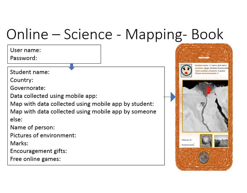
3. The mobile application is used to collect data about the environment, science citizens or farmers or children can use app to record data about snails’ samples that are collected from canals, and to take taking photos of vegetation types around water canals, and any source of pollution. Students can share their data, photos and findings on an online science book where the background is a visual map. Physicians and health workers can use the application to map where people are infected by schistosomiasis.
4. Application uses the output of different research results, input from science citizen and government strategy to inform concerned farmers where schistosomiasis is likely so they avoid these canals. Application will inform the governmental employees who are responsible to kill these snails, so they remove vegetation that hosts these snails or they clean water canals or use other environmentally friendly methods to get rid of these snails.
5. In some areas schistosomiasis infect children when they swim in canals. Suggested application will have a possibility to detect children locations (x,y) and detects if they are near a canal that has schistosomiasis, and the application will alarm their mothers or teachers, then mothers or teachers can call these children to tell them not to swim. In addition, this can be repeated with farmers and application can inform hospitals that these farmers may got infected by schistosomiasis.
[1]‘WHO | What is schistosomiasis ?’, WHO. [Online]. Available: http://www.who.int/schistosomiasis/disease/en/. [Accessed: 20-Oct-2018].
[2]A. Jemal, F. Bray, M. M. Center, J. Ferlay, E. Ward, and D. Forman, ‘Global cancer statistics’, CA. Cancer J. Clin., vol. 61, no. 2, pp. 69–90, Feb. 2011.
[3]‘WHO | Strategy’, WHO. [Online]. Available: http://www.who.int/schistosomiasis/strategy/en/. [Accessed: 20-Oct-2018].
[4]Y. Walz, M. Wegmann, S. Dech, G. Raso, and J. Utzinger, ‘Risk profiling of schistosomiasis using remote sensing: approaches, challenges and outlook’, Parasit. Vectors, vol. 8, Mar. 2015.
[5]J. A. Clennon, C. H. King, E. M. Muchiri, and U. Kitron, ‘Hydrological modelling of snail dispersal patterns in Msambweni, Kenya and potential resurgence of Schistosoma haematobium transmission’, Parasitology, vol. 134, no. Pt 5, pp. 683–693, May 2007.
[6]H. Xu, ‘Modification of normalised difference water index (NDWI) to enhance open water features in remotely sensed imagery’, Int. J. Remote Sens., vol. 27, no. 14, pp. 3025–3033, Jul. 2006.
[7]C. Kalinda, M. J. Chimbari, and S. Mukaratirwa, ‘Effect of temperature on the Bulinus globosus — Schistosoma haematobium system’, Infect. Dis. Poverty, vol. 6, no. 1, p. 57, May 2017.

SpaceApps is a NASA incubator innovation program.