


The Challenge | Health Makes Wealth
airQ
A System that is used to collect and display Air Quality data to a variety of users, designed for the benifts of the health of people and nature in mind.
Air_Q is a system that is used for measuring the Air Quality in a location that the user chooses or locating him via GPS tracking. The App would show the air quality in the general location first, with a peripheral sensor in the form of a ring or accessory giving more specific citizen data.
The App uses data from Aqicn data repositories and user submitted data. It processes this information to display it with a GUI in a mobile app form. The Peripheral Sensor would communicate with the users mobile device via Bluetooth, the mobile device communicates with a data store to store this data.
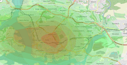
The GUI would present the data to the user in a heat map format in six different levels of air pollution that are represented by an AQI (Air Quality Index). Each one of them correlates to a colour concentration with its related health warnings. These are applied to heat-map to display the distribution of air pollution. The heat-map will also display a lack of data in a specific area when local data from sensors will be absent, this could also subconsciously push the user to go into such areas to 'complete the map'.
The app allows users to see the air conditions on the route they usually take, this is beneficial for individuals who live a healthy lifestyle or have health conditions such as asthma. It will also have positive impact on the nature and fauna thanks to users' desire to live in cleaner environment. The app would also have a feature to display historical data in a list format for a location specified by the user.
Companies or local government organisations could also install sensors at fixed positions, these would display the pollution levels in an area more reliably. They could be used by companies to prove how eco-friendly they are, benefiting everyone as it would be increasing the collected data set. Increasing the accuracy and reliability of the system.
The mobile app option has an 'about' section on the app that would display what each 'buzzword' means. I.E. The definition of Co2 or Methane. This would be useful for educating a younger demographic of users while the collected data itself is usable in higher level academic papers.
Sources:
http://www1.heatmapper.ca/geocoordinate/

SpaceApps is a NASA incubator innovation program.