


Satify | Looking GLOBE-ally
Team Updates
Additional information is available at:
Demo and database can be accessed via the following links:
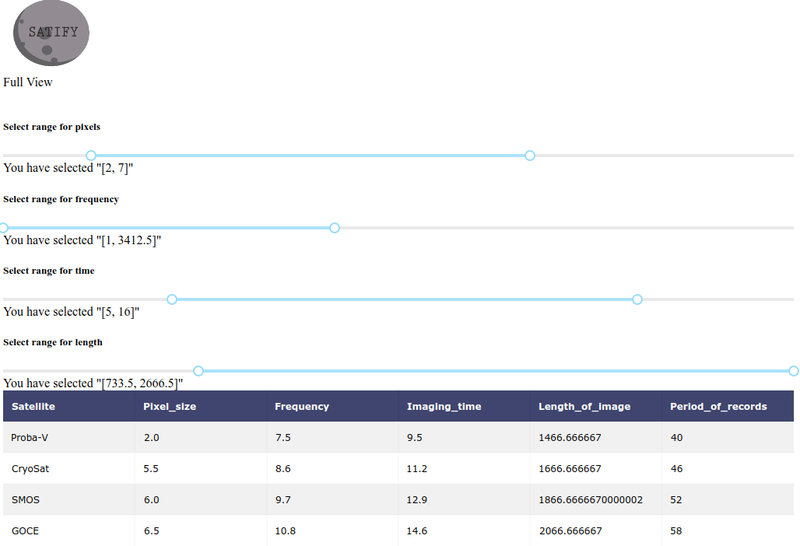
DATABASE: Satellites and respective image quality indicators
Problem description
Many satellites provide information about land surface temperature (LST), vegetation status (e.g. NDVI), soil moisture or other parameters. However, they differ by pixel size of the image, frequency of taking image at the same point/study area, length of the image time series etc.
Manually sorting out all publicly available data sets form different data providers is time consuming. An automated search engine could easily rank all data sets to tabular form to make it easier for users to look for the interested parts.
Time to solve: around 1,5 day
Solution
- A WEB APP:
1. Provides data on the quality of datasets of satellites in a tabular form.
2. Provides range sliders to allow filtering of available data on the quality of datasets.
- A MOBILE APP (Android):
1. Provides data on the quality of datasets of satellites in a tabular form.
2. Provides range sliders to allow filtering of available data on the quality of datasets.
Limitations
The current solution does not provide automated search for data on spatial resolutions of images obtained from satellites. Nevertheless, the app automatically filters out satellites according to the looked for spatial resolutions or other image related parameters.
There are no known available databases containing sorted data on the quality of datasets. Thus, the database for this app was populated manually by gathering information from different online resources.
Suggestion for future improvements
There were some quality indicators introduced for different satellites such as Landsat (1-8) and Sentinel (1-6) by governing agencies.The search engine could be developed to automatically populate database on quality of datasets using data in accompanying files from the downloaded datasets.
Since the app is provided as an open-source project, all the necessary improvements can be facilitated by collaboration with the community of software developers.
Resources for future improvements:
https://opensource.gsfc.nasa.gov/projects/DQSS/ind...
Credits:
Web App: Prabhant Singh
Mobile App: Muazzamkhon Yusupova, Mehin Salimli, Avantika Arya Agrawal
Database: Nodirkhon Yusupov and Jhalak Sethi
Idea and guidance: Dr. Ain Kull and Dr. Alexander Kmoch (Department of Geography, University of Tartu, Estonia)
Mentors: Martin Jüssi

SpaceApps is a NASA incubator innovation program.