


PerIgnemAdAstra | Spot That Fire!
The Challenge | Spot That Fire!
CFDS Crowd Fire Detection System
Integration of the current information from NASA satellites with data submitted by people to have a faster detection of wildfires and alert people near them.
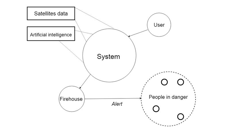
We are building a web app that allows a user to anonymously report a fire nearby, to see all fires detected by NASA MODIS satellite in the last 24 hours and fires reported by other users.
All reports will be filtered by an AI and then stored.
On another side a fire station checks all the reports that pass the filter and can send an alert to people in a dangerous area.
Server side we are using Node.js.
We are using heroku to host our web app.
We are using open street map to visualize the data on a map.
We are using Clarifai to do image recognition to filter our fire reports.
To be able to reach people and notify people without an app we are building a social media infrastructure made of a messanger bot on a facebook page, and a telegram bot.
SOCIAL MEDIA INTEGRATIONWe want to have a bot with the following features:
- Send news about current most dangerous fires
- Send info about nearby fires using the user current position
- Add a new to the server database
We also would like to have a Telegram channel that periodically sends news about most dangerous fires in the world.
What we can do right now:
- we can show the last 24 hours detected fires from MODIS but we have not automated the gathering of the data.
- a user can send a report by selecting a point on the map and it will show up on the map. We also have geolocalization to send user current position, however it only works on our localhost prototype since our server is not set on https.
- user can upload a photo when sending a report
- with image recognition we check if the photo contains fire, if so we accept the report, otherwise we discard it
- weather data from open weather is displayed on reported locations
What would be good to have (but we don't have in our prototype, yet):
- an actual mobile app would be so much better for the fact that we could push alert notifications to the users but a web app is just so faster to build for a prototype
- the fire station side is left as jut an idea due to timing.
- a database to store reports to build up new datasets

SpaceApps is a NASA incubator innovation program.