


Team Quadra | Don’t Forget the Can Opener!
The Challenge | Don’t Forget the Can Opener!
Observe The Earth And Save The Season
A weather based mobile application (open source project) which will use GPS, internet connection, earth’s atmospheric data to observe the data of NASA regarding earth’s various disasters like flood, drought, tsunami etc.
Background:
A weather based mobile application which will give the necessary atmospheric information to response to the danger.
Description:
Summary:
“Observe the earth and save the season” is the main goal of our app. It interacts with various atmospheric data and provide necessary weather information to user to find out the danger and take precautions. This is an open source app and is very user friendly.
Our app:
“Weather cast live” app for Android provides detailed weather in more than 200 cities.
Features:
What our app does ?
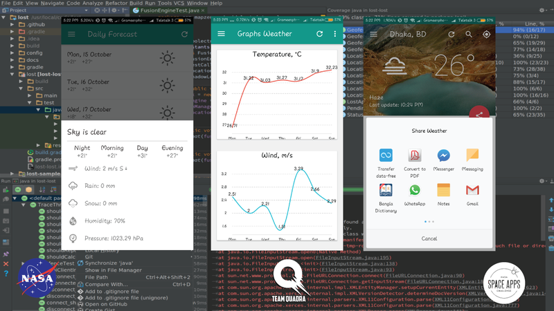
The main goal of our app (weather cast live) is to give globally necessary weather based information to its user regarding their current atmospheric situation. It provides the current location weather even in very low internet connection like 2G internet, which includes temperature, wind speed, humidity, pressure, cloudiness, sunrise, sunset etc. Greatest features is that it can run on any version of android OS & runs the app properly in 2 second. It uses 0.50kb-15kb to give all of the featured weather information, which also takes only 1 to 3 seconds. It will also refresh in every 15 minutes and give a notification to the user about the current situation. User can also add widget of this app to get the real time forecast. It also have the graphical image option which shows the graphical weather. It can also show the upcoming 7 days graphical weather forecast which includes predicted wind speed, temperature, rain, snow, humidity & pressure. It is weather based mobile application (open source project). Moreover for poor people it is a very light app which uses very low internet connection and run also in lower end smartphone (at present Android). So, they will get the necessary atmospheric information to response to the danger. It is weather based mobile application (open source project) which will use internet connection, earth’s atmospheric data to observe the data of NASA regarding earth’s various disasters like flood, drought, tsunami etc. These data will help us to compare the current situation of the surrounding environment and find any imbalance or unusual activity of the environment. We will find information about hazardous things on that location which can cause danger to the inhabitants of the environment if any natural disaster takes place. By the help of this weather cast we will be able to get the information about the initial impacts of those disasters on real life and property. These process will be based on various forecasting source and NASA’s earth atmospheric observation data. This app will analyze & monitor NASA data, images, videos, or data visualizations to illustrate disaster type, to help people understand how to prepare.
Future Plan:
Others:
Resource:
NASA open source link:
http://sedac.ciesin.columbia.edu/data/set/ndh-cycl...
https://assets/images.nasa.gov/
https://appliedsciences.nasa.gov/programs/disaster...
https://www.nasa.gov/mission_pages/neowise/main/in...
https://www.earthdata.nasa.gov/
https://github.com/google/gson
https://www.flickr.com/photos/kc2daniel/9694177482...
https://github.com/PhilJay/MPAndroidChart
https://github.com/google/roboto/
https://erikflowers.github.io/weather-icons/

SpaceApps is a NASA incubator innovation program.