Flight Star | Invent Your Own Challenge
Team Updates
The planets, map of transformation weather, populations
Map the Locations of Moon Landings
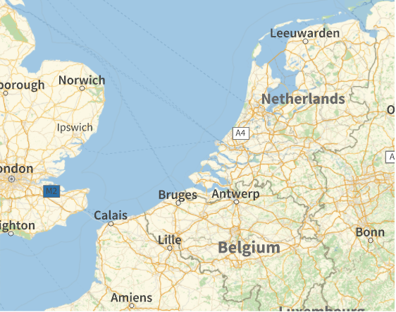
GeoGraphics[{GeoPosition[{50, 0}], \!\(\*NamespaceBox["LinguisticAssistant",DynamicModuleBox[{WolframAlphaClient`Private`query$$ = "Netherlands", WolframAlphaClient`Private`boxes$$ = TemplateBox[{"\"Netherlands\"", RowBox[{"Entity", "[", RowBox[{"\"Country\"", ",", "\"Netherlands\""}], "]"}], "\"Entity[\\\"Country\\\", \\\"Netherlands\\\"]\"", "\"country\""}, "Entity"], WolframAlphaClient`Private`allassumptions$$ = {{"type" -> "Clash", "word" -> "Netherlands", "template" -> "Assuming \"${word}\" is ${desc1}. Use as \${desc2} instead", "count" -> "2", "Values" -> {{"name" -> "Country", "desc" -> "a country", "input" -> "*C.Netherlands-_*Country-"}, {"name" -> "MusicAlbum", "desc" -> "a music album", "input" -> "*C.Netherlands-_*MusicAlbum-"}}}}, WolframAlphaClient`Private`assumptions$$ = {}, WolframAlphaClient`Private`open$$ = {1, 2}}, DynamicBox[ToBoxes[AlphaIntegration`LinguisticAssistantBoxes["", 1, Dynamic[WolframAlphaClient`Private`query$$], Dynamic[WolframAlphaClient`Private`boxes$$], Dynamic[WolframAlphaClient`Private`allassumptions$$], Dynamic[WolframAlphaClient`Private`assumptions$$], Dynamic[WolframAlphaClient`Private`open$$]], StandardForm],ImageSizeCache->{182., {7., 15.}},TrackedSymbols:>{WolframAlphaClient`Private`query$$, WolframAlphaClient`Private`boxes$$, WolframAlphaClient`Private`allassumptions$$, WolframAlphaClient`Private`assumptions$$, WolframAlphaClient`Private`open$$}],DynamicModuleValues:>{},UndoTrackedVariables:>{WolframAlphaClient`Private`open$$}],BaseStyle->{"Deploy"},DeleteWithContents->True,Editable->False,SelectWithContents->True]\)}]
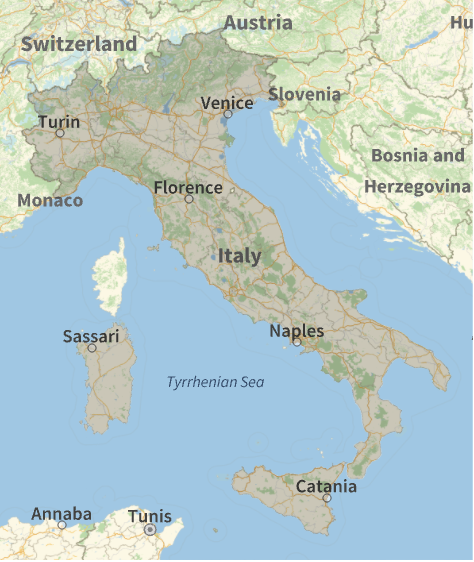
GeoGraphics[{EdgeForm[Black], FaceForm[Red], Polygon[\!\(\*NamespaceBox["LinguisticAssistant",DynamicModuleBox[{WolframAlphaClient`Private`query$$ = "Italy", WolframAlphaClient`Private`boxes$$ = TemplateBox[{"\"Italy\"", RowBox[{"Entity", "[", RowBox[{"\"Country\"", ",", "\"Italy\""}], "]"}], "\"Entity[\\\"Country\\\", \\\"Italy\\\"]\"", "\"country\""},"Entity"], WolframAlphaClient`Private`allassumptions$$ = {}, WolframAlphaClient`Private`assumptions$$ = {}, WolframAlphaClient`Private`open$$ = {1, 2}}, DynamicBox[ToBoxes[AlphaIntegration`LinguisticAssistantBoxes["", 1, Dynamic[WolframAlphaClient`Private`query$$], Dynamic[WolframAlphaClient`Private`boxes$$], Dynamic[WolframAlphaClient`Private`allassumptions$$], Dynamic[WolframAlphaClient`Private`assumptions$$], Dynamic[WolframAlphaClient`Private`open$$]], StandardForm],ImageSizeCache->{109., {7., 15.}},TrackedSymbols:>{WolframAlphaClient`Private`query$$, WolframAlphaClient`Private`boxes$$, WolframAlphaClient`Private`allassumptions$$, WolframAlphaClient`Private`assumptions$$, WolframAlphaClient`Private`open$$}],DynamicModuleValues:>{},UndoTrackedVariables:>{WolframAlphaClient`Private`open$$}],BaseStyle->{"Deploy"},DeleteWithContents->True,Editable->False,SelectWithContents->True]\)]}]
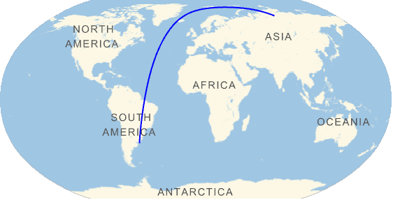
With[{locations = {GeoPosition[{-35, -55}], GeoPosition[{70, 100}]}}, GeoGraphics[{{Blue, GeoPath[locations, "Geodesic"]}}, GeoRange -> "World", GeoProjection -> "Robinson"]]
Vonfram programming to Python (http://www.wolframcloud.com/objects/92a75bc9-fffd-...):
Vonfram programming language
EmbedCode[APIFunction[GeoGraphics[Entity["SolarSystemFeature", "OlympusMonsMars"],
GeoRange -> Quantity[400, "Miles"]]], "python"]
Python:
from urllib import urlencode
from urllib2 import urlopen
class WolframCloud:
def wolfram_cloud_call(self, **args):
arguments = dict([(key, arg) for key, arg in args.iteritems()])
result = urlopen("http://www.wolframcloud.com/objects/92a75bc9-fffd-4036-a96c-278b7ea27abb", urlencode(arguments))
return result.read()
def call(self, ):
textresult = self.wolfram_cloud_call()
return textresult
GeoGraphics[Entity["SolarSystemFeature", "OlympusMonsMars"], GeoRange -> Quantity[400, "Miles"]]
SpaceApps is a NASA incubator innovation program.
