


Splendor | Spot That Fire!
The Challenge | Spot That Fire!
Laheeb
Notify • Extinguish • Rescue
In the years from 2000 to 2010 In The United States Of America, the average number of acres that have been burned is 1,610,142 ac. and the average number of fires is 9,220 fire. which result in 192.1 Acres per Fire.
- (NOAA) National Center For Environmental Information https://www.ncdc.noaa.gov/sotc/fire/201807
The problem of wildfires:
1- Hard to predict.
2- Spread quickly.
3- Difficult to control.
We decided to solve this challenge by introducing 3 solutions in ONE APP.
The solutions:
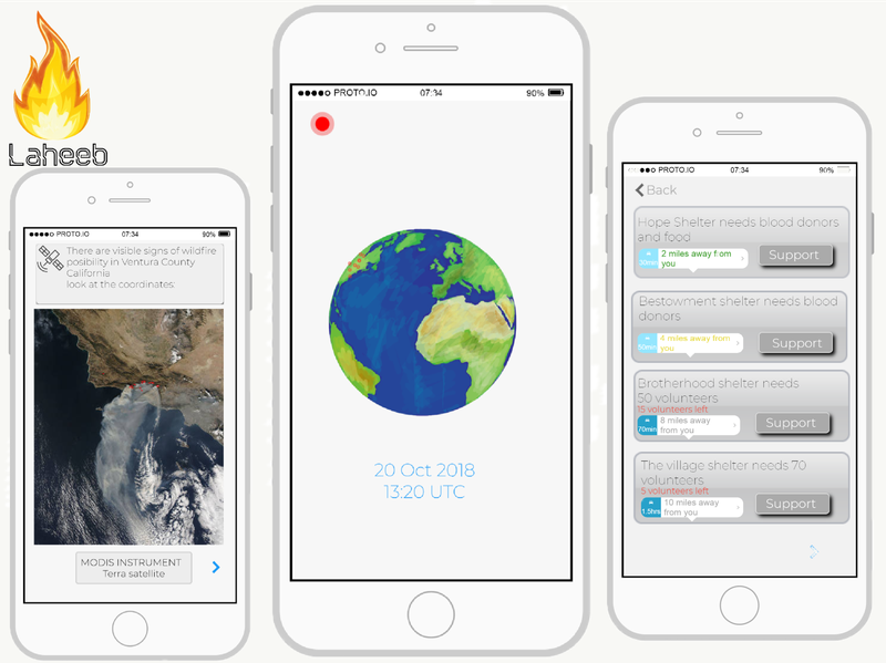
1- Pre Wildfire: We Put a system that can predict wildfires before they occur for our Laheeb app. We gather open source NASA data set for wildfires across the globe and train a Machine learning tool to predict wildfires with NASA MODIS instrument wildfires data. by gathering and analyzing the wildfire sites, temperature degree and vegetation cover by using SeaWiFs satellite and instruments including the NASA/NOAA. therefore, we train these data set in our system and improving them more from the future wildfire coordinates by NASA MODIS instrument to be able to predict wildfires accurately.
2- While Wildfire: our Laheeb App will cooperate with :
A- People : once the wildfire starts we notify the people around the fire site to go to the nearest shelters around them and guide them using a GPS system.
and for the people who want to volunteer and support the victims of wildfire we guide them to the nearest shelters and hospitals and provide them with information about institutions needs e.g. blood donors, food…etc.
B- Institutions (fire departments, hospitals and shelters) : with MODIS instrument we can discover the early beginning of the wildfire even if it wasn’t accompanied by any smoke and GOES satellite (which is operated by NOAA but was designed and built by NASA. therefore, we notify these institutions with the fire site so the fire fighters extinguish the wildfire before it gets out of control and prioritize the extinguishing according to vegetation cover because there are plants that burn faster than any other plants e.g. shrubs and coniferous trees. As for hospitals and shelters they can prepare efficiently for the people who would come over for support.
3- Post Wildfire: In our app, We put highlighted spots to the map coordinates of the wildfire sites that have already happened so the people & institutions know about these sites and take care of them in the future with better preparation.
Finally, Laheeb can work offline by linking its system to NASA data, GPS system and SMS.
in the updates section you can see the app screens with brief explanation.
Resources:
SeaWiFS satellite and NASA/NOAA instruments:
https://climate.nasa.gov/news/2652/the-changing-co...
GOES satellite and MODIS instrument:
https://www.nasa.gov/feature/goddard/2018/nasa-covers-wildfires-from-many-sources
https://www.popsci.com/nasas-weather-satellite-lau...
How different treespecies impactthe spread of wildfire:
https://www1.agric.gov.ab.ca/$department/deptdocs.nsf/all/formain15744/$FILE/tree-species-impact-wildfire-aug03-2012.pdf
facts and statistics of wildfires:
https://www.iii.org/fact-statistic/facts-statistic...

SpaceApps is a NASA incubator innovation program.