


Pyro Pandas | Spot That Fire!
The Challenge | Spot That Fire!
HotSpot
HotSpot is a crowd sourced fire detection system using NASA World Wind to collect location information on a reported fire.
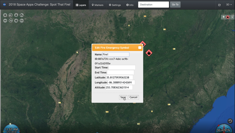
HotSpot is a crowd source fire detection system using NASA World Wind. HotSpot allows a user to place a marker where a fire has started and records the geo-location of the fire. The app also shows the user locations of reported fires from information gathered by NASA.
App Link: nasaspaceappschallenge2018.ddns.net:8080
GitHub Repos:
github.com/mmahann/FireRestAPI
github.com/mmahann/WorldWindExplorer
This tool could give authorities advanced warning about fires and allow them to respond more quickly. With the ability for anyone to immediately record the location of a fire when they see it, fire fighters can more accurately respond to the situation before it gets out of hand.
With the limited timeframe the project currently is limited to only existing nasa data and user added data. Future additions could include a variety of features including:
- Add in other user features
- Ability to upload photos to the GEOTag
- Ability to add other relevant data
- GEOTag twitter type chat feed
- Additional data sources can be pulled into HOTSPOT from other sensor sets
- Weather Data
- Additional Satellite resources
- Pull in IR and other sensory data from additional resources (commercial and governments around the globe)
- Civic data sets (fire hydrant, electrical, water system locations)
- Capture Reporting User information for later forensics use
- Cell Number, IP Address Automatically
- User Login Information (Name, Address, etc)
- Verify where user is placing GEOTag is relevant to their reporting position
- Utilize GEO info in the photo to adjust GEOTag location
- Add in location data for residents
- Could add user phone location GPS data
- Add in individual firefighter/responder geo locations
- Artificial Intelligence
- Add in predictive algorithms for
- Fire movement, expansion based on changing weather patterns
- Alert ground units of changing conditions
- Fire changing path toward them
- Evacuation route is shrinking (box in risk)
- Fire confirmation utilizing computer vision
- Alert on resident evacuations recommendation based on changes in the fire
- Add in predictive algorithms for
Tools Used:
- NASA World Wind Web
- NASA Earth Observations WMS
- Digital Ocean
- Docker
- Apache
- Node.JS
- PostgreSQL
We are a college/professional team

SpaceApps is a NASA incubator innovation program.