


Google it | Spot That Fire!
Awards & Nominations
Google it has received the following awards and nominations. Way to go!
The Challenge | Spot That Fire!
SpotFire: Making the earth safer
A crowd-sourcing tool for citizens to contribute to early detection, verification, tracking, visualization, and notification of wildfires.
Links:
Problem Background
Over the past year, we have witnessed long and arduous battles against record-breaking wildfires across the world.
Some of these fires burned thousands of acres of land and destroyed hundreds of homes and buildings. Additionally, smoke from the fire creates issues related to poor air quality, raising health concerns for people not just in the vicinity of the fire, but at distances hundreds of miles away.
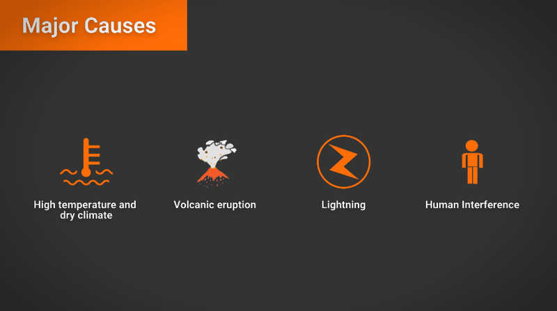
Major Causes
Case study: USA [1]
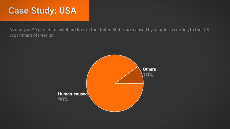 Some human-caused fires result from campfires left unattended, the burning of debris, negligently discarded cigarettes and intentional acts of arson. The remaining 10 percent are started by lightning or lava.
- According to Verisk’s 2017 Wildfire Risk Analysis 4.5 million U.S. homes were identified at high or extreme risk of wildfire, with more than 2 million in California alone. Losses from wildfires added up to $5.1 billion over the past 10 years.
- From January 1 to October 12, 2018, there were 49,658 wildfires in the U.S, compared to 51,126 wildfires in the same period in 2017, according to the National Inter-agency Fire Center.
- About 8.1 million acres were burned in the 2018 period, compared with 8.6 million in 2017.
Our Solution Overview
Spotfire, a crowd-sourcing tool that can support real-time detection and monitoring of wildfires; improving environmental safety to preserve it from wildfire risk.
Spotfire, allows users to report wildfires with different means, and provides experts with the means to monitor them and make predictions.
This real-time submission of images, videos, and people comments and observations, provides crucial onsite information and can provide great help into building a wide picture of the problem for it to be properly contained; allowing people even thousands of miles away, and even those without televisions, to be notified with live pictures/videos, expanding our data collection and providing experts with various data sources to track and monitor wildfires to gain insights, make predictions, and give warnings to potential disasters. This would also raise the public’s awareness of that specific disaster.
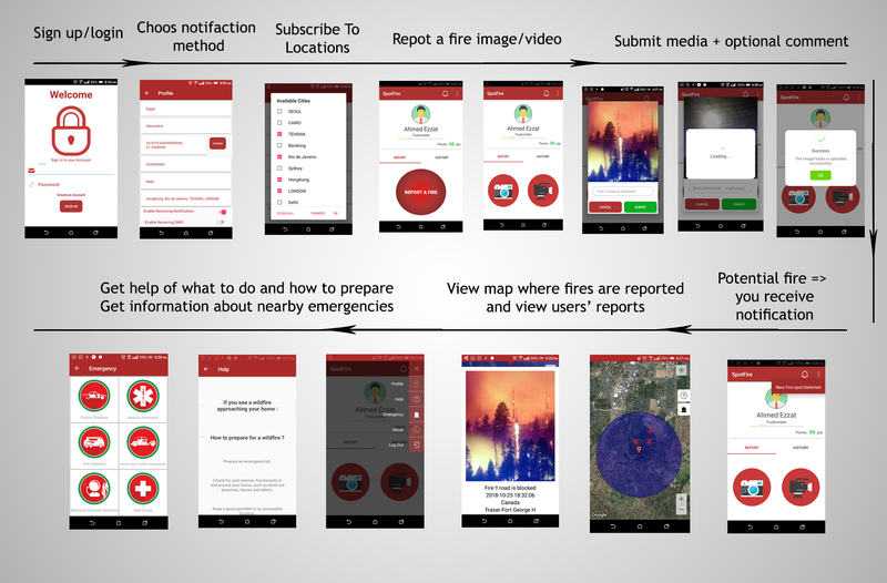
Scenario/ User Journey
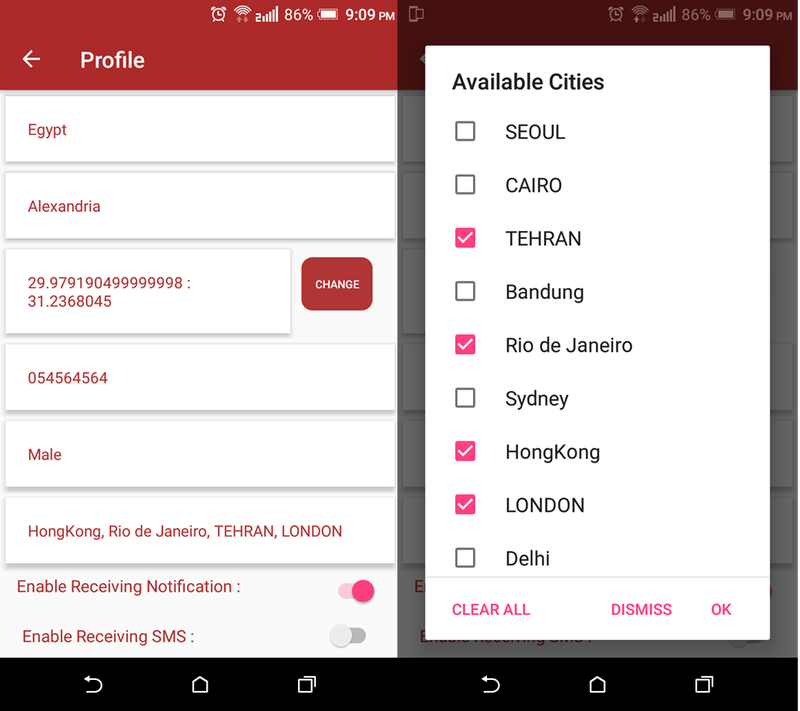
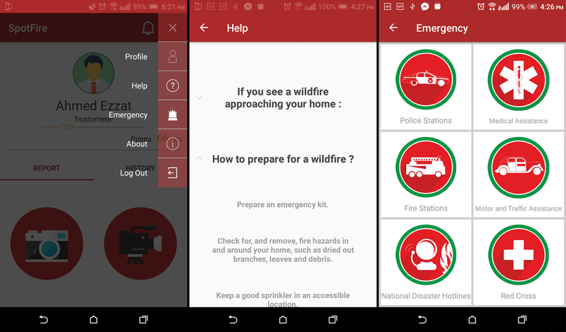
* Each user has a profile and reporting history. He can choose a notification method, and subscribe to different locations to be notified if a wildfire occurs.
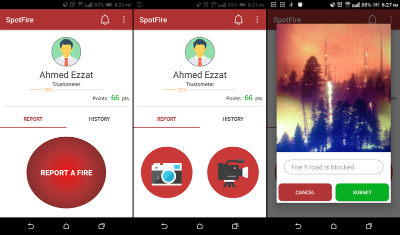
1- A user reports a wildfire in real-time by taking an image/video with an optional comment about the situation; are there injuries? are there blocked roads? how bad is the situation?
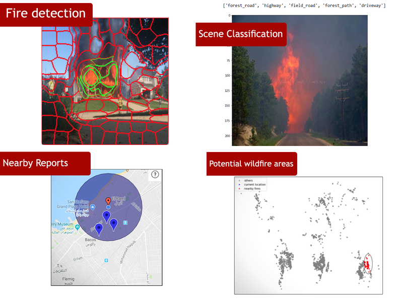
2- Once the report is submitted, it enters the verification phase; using machine learning and deep learning techniques alongside NASA database and other resources [3] we can answer the questions:
- Is the submission fire related? (wildfire detection model [4])
- Are there elements in the scene that are a sign of wild or rural areas? (scene classification model [5])
- Are there wild areas near the user?
- Do they have previous records of wildfires? And how they relate to NASA's live wildfires data?
- Are there nearby people who report a similar incident?
- Can the weather info help?
- We also track the user's reporting history to build a trust rate.
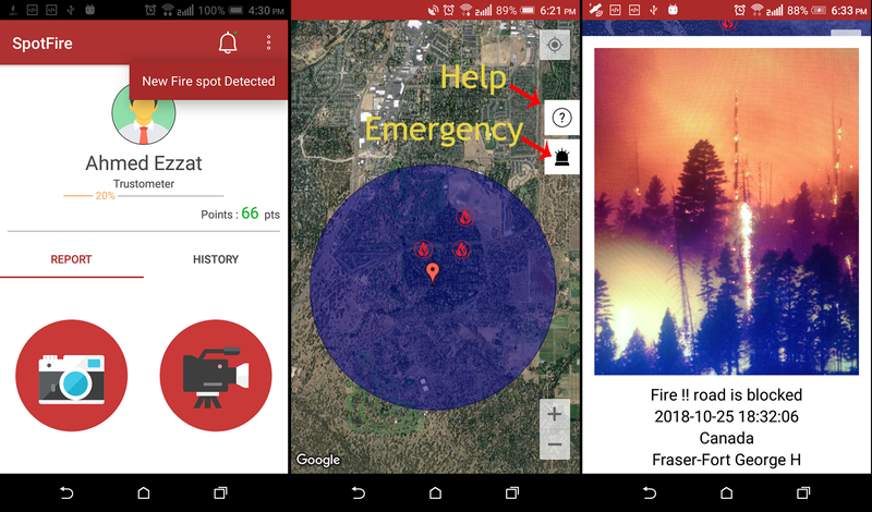
4- Furthermore, through an intuitive visualization, and using the collected data and the real-time submissions alongside NASA database and various data sources, experts can use the web platform to track and monitor these data to gain insights, make predictions, and give warnings to potential disasters. And users are able to see wildfires occurrences worldwide.
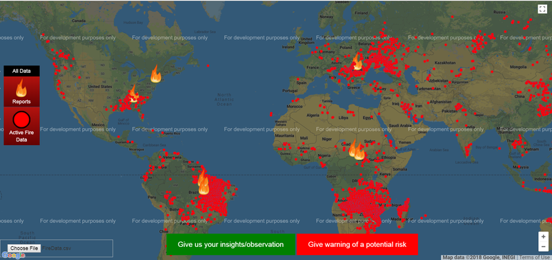
* Weather data, Fire Email Alerts, and Earth heatmap are under development to further increase the knowledge, and help widen the scope to get better insights and observations.
Improvements & Future Work
- Analyzing data and clustering reports to gain insights about common areas at high risk, and which areas need more or nearer fire-stations.
- Integrate Geo-spatial data from various sources to provide innovative services to citizens (e.g., local weather and local traffic)
- Improving social media reach, by automated tweeting/posting of highly trusted reports to inform the news and general public.
- Heroes who helped in wildfires detection, saving lives and properties, will be offered with special prizes, and will be announced in our hall of fame on the social, to engage the public and encourage citizen participation.
Impact
We think SpotFire can greatly support real-time detectionand monitoring of wildfires and it can be a great contribution to help us facing such disaster. It would have impact on:
- Rescue teams and victims:
- The victims and rescue teams may be able to submit real-time reports of the disaster in order to notify entities who can help and send updates of the situation.
- Local government:
- With historical records and the monitoring page, high-risk areas can be identified. Development plans in those areas can be further assessed accordingly.
- When a wildfire occurs, the real-time reports would improve the efficiency of all efforts and minimize death and property loss.
- After communicating with the authorities concerned, regulations can be established and implemented to help the government obtain funding for disaster relief.
- NASA:
- This expanding data collection, users' real-time reports, previous records, and experts contributions to give insights, predictions, observations and recommendations will help expand NASA’s own database and improve the quality of data prediction.
- Global community:
- Users can help early detection and prevention of wildfires through their contributions and reporting.
- Users are able to see wildfires occurrences worldwide. This brings more attention to wildfires occurring in other countries and raises the public’s awareness of that specific disaster.
- When a disaster strikes, concerned citizens all over the world can pitch in and help out with disaster relief.
- Experts all around the world have access to the data sources and can track and monitor wildfires to gain insights and give warnings to potential disasters.
Used Technologies
- Android
- Fire-base
- Python, Keras, Tensorflow
References
[1] Wildfires facts and statistics:
https://www.iii.org/fact-statistic/facts-statistic...
[2] Wildfires, Causes and Evaluations:
https://www.nps.gov/articles/wildfire-causes-and-e...
[3] NASA fire database:
https://earthdata.nasa.gov/earth-observation-data/...
[4] Fire Detection and localization:
https://breckon.org/toby/publications/papers/dunni...
https://github.com/tobybreckon/fire-detection-cnn
[3] Scene Classification
Team
Ahmed Ezzat
Linkedin: https://www.linkedin.com/in/aemaghawry/
Ahmed Rizk
Linkedin: https://www.linkedin.com/in/ahmed-rizk1419/
Yahia El-shahawy
Linkedin: https://www.linkedin.com//in/yahia-el-shahawy-204bb212b/
Youssef Ahmed Mubarak

SpaceApps is a NASA incubator innovation program.