


Alpha Team | Don’t Forget the Can Opener!
The Challenge | Don’t Forget the Can Opener!
Alpha Solutions
Alpha Solution is a system designed to decrease casualties in disasters, by alerting the population that is inside a dangerous zone, and informing them about ways to stay safe!
- Challenge:Don’t Forget the Can Opener!
- Introduction, who we are:
Alpha Solution is a system designed to decrease casualties in disasters, by alerting the population that is inside a dangerous zone, and informing them about ways to stay safe!
- Problem Statement:
In the last 10 years, over 1.7 Billion lives are affected by disasters, 700 Thousand have died during this timespan, damages of over 1.4 Trillion dollars have been caused, in some parts of the world, where populations may be more demographically diverse, getting out earthquake-preparedness information can be challenging.
- Our solution:
Our system is designed to use the latest disaster predictions, and using satellite communication to alert all people inside an area that will be in danger, and give a list of safety tips on what to do.
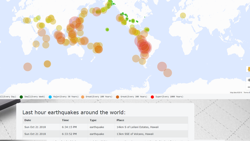
It also includes a link to our website, where people with access to the internet can see visually and precisely the disasters around them!
We extract data from National Earthquake Information Center (NEIC). NEIC is part of the Department of the Interior, U.S. Geological Survey, and it has three main missions:
- NEIC determines, as rapidly and as accurately as possible, the location and size of all significant earthquakes that occur worldwide. The NEIC disseminates this information immediately to concerned national and international agencies, scientists, critical facilities, and the general public.
- NEIC collects and provides to scientists and to the public an extensive seismic database that serves as a solid foundation for scientific research.
- NEIC pursues an active research program to improve its ability to locate earthquakes and to understand the earthquake mechanism.
- NEIC collects data through the operation of national and global networks, and through cooperative agreements.
- NEIC also relies on the cooperation of a variety of seismic reporting networks throughout the world to gather data.
- How we process that data:
1.We get the most recent data for upcoming earthquakes from NEIC
2.Our platform processes the data, and sends alert messages to the citizens of the danger zone.
3.Citizens receive the alert, and
- How we communicate with the satellites:
a)All satellites communicate with Earth and vice versa through radio signals, so there would be a radio transmitter on the satellite, and that sends a signal down to a receiver on the ground.
b)Satellites communicate with Earth by using radio waves to receive and send signals to the antennas on. The antennas then capture those signals and process the information coming from those signals.
- How Satellites alert the people in danger:
Upon receiving the data about the endangered locations, the satellites use The Personal Localized Alerting Network (PLAN) to alert all the people inside the endangered area, PLAN is a new public safety system that allows customers who own an enabled mobile device to receive geographically-targeted, text-like messages alerting them of imminent threats to safety in their area.
- How “PLAN” works:
1.Authorized national, state or local government officials send alerts regarding public safety emergencies to PLAN
2.PLAN authenticates the alert, verifies that the sender is authorized, and sends it to participating wireless carriers
3.Participating wireless carriers push the alerts from cell towers to mobile phones in the affected area. The alerts appear like text messages on mobile devices.
- Solution: What happens after receiving the alert?
The endangered population is immediately presented with a list of safety tips, and they are also presented with a link to our website, for people who have internet access, so they can see visually and precisely where is the closest point of danger, and even more safety tips.
Safety tips would contain information such as:
- Type of disaster:
- Level of the risk
- Tips to stay safe
- Checklist of equipments/materials the citizen should posses
- Reply SMS to “PLAN”, if the citizen is “Safe”, “Not Safe” or “Needs Help”
- Evacuation plan: meeting point
- Our team:
1.Berat Nebiu
2.Jetron Saiti
3.Drin Kadriu
4.Enes Bajrami
5.Artan Aliji
6.Ali Sylejmani
A link to our open-source project: https://github.com/frozen0/Alpha
- Resources:
The resources that were used are the resources that were shared by the NASA team.
-https://appliedsciences.nasa.gov/programs/disaster...
-https://www.nasa.gov/mission_pages/neowise/main/in...
-https://www.earthdata.nasa.gov/

SpaceApps is a NASA incubator innovation program.