


W-Mars | Make Sense Out of Mars
Awards & Nominations
W-Mars has received the following awards and nominations. Way to go!
The Challenge | Make Sense Out of Mars
W-MARS
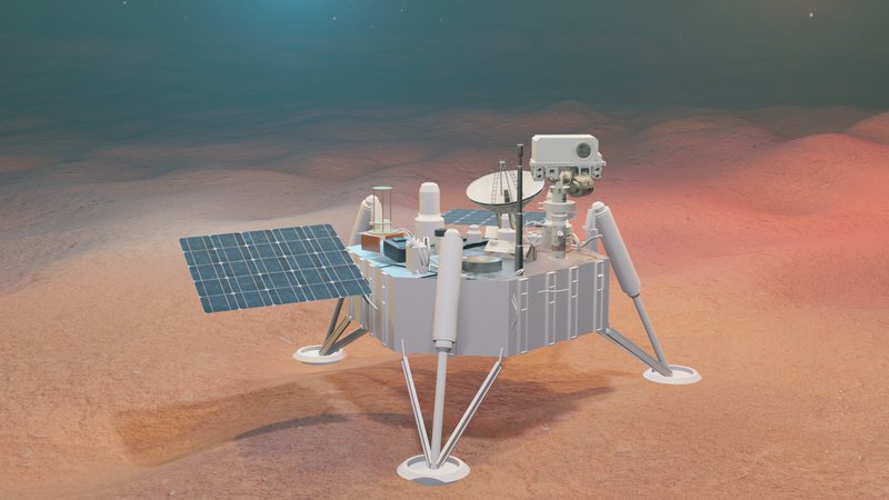
To solve the challenge "Making Sense Out Of Mars", we created W-MARS. Our aim is to provide environmental data of Mars and install a local network. Our product consists of deploying many capsules by aeroshells on fixed locations around the Red planet.
Motivation
- NASA’s ambitious long term plan for establishing a Mars colony by 2030 created the need to learn more about the Red Planet and examine any poisonous elements for humans. The Mars exploration can also lead to clues about any ancient life there.
- In the near future, it is predicted that the Red Planet can serve as a back-up plan for the human race to survive. The threats on Earth consist of extinction cycles, global warming, nuclear proliferation...etc. The Earth's resources are also being cut short and it will no longer suffice 7.7 billion people.
- Educating the next generations about the Red Planet is critical to ignite passion and interest about our next potential home.
- In 2006, an unplanned malfunction in the wheels of a Mars rover, obliging it to stay in one place, lead it to discover water-altered minerals in the martian soil.
Proposed solution
The purpose of the challenge is to develop a sensor to be used by humans on Mars. To solve this challenge, “Make Sense Out Of Mars”, we created “W-Mars”. Our aim is to provide an environmental analysis of several places around Mars and establish a local network and time zones to help NASA re-engineer the Red Planet. Our product consists of fixable metallic capsules designed to be deployed by aeroshells on diverse locations on Mars. The sensors placed on the capsules will allow them to collect data about several parameters: atmosphere, soil, core and ancient life. This data will be exchanged between the capsules and transferred to Earth for future investigations. On Earth, the light data will be analysed by NASA to set martian time zones, whereas the images will be used on the Mars Educational app to provide a VR simulation for the public.

Objectives
The main objectives of our product are:
- Collect environmental data from different areas during a whole martian year.
- Create a local network for the capsules to communicate between each other.
- Define time zones on Mars.
- Educate the next generations through the Mars Educational VR App.
Details
Find below the different aspects of our project:
Environment :
Even if Mars is devoid of past or present life, however, there's still much excitement on the horizon. We ourselves might become the "life on Mars". Meanwhile, we still have a lot to learn about this amazing planet and its extreme environments.
W-MARS uses different capsules that seek to understand whether Mars was, is, or can be, a habitable world. To find out, we equip our capsules with different sensors to get the maximum of data from Mars’ environment.
In addition to nano and micro sensors, we employ NASA technologies used in Curiosity rover
- Mast camera (Mastcam): To take panoramic color images of the surface and atmospheric features and the terrain ahead of the rover.
- Mars Hand Lens Imager (MAHLI): Microscopic Imaging of minerals, textures and structures in rocks and soil at scales smaller than the diameter of a human hair.
- Alpha Particle X-Ray Spectrometer (APXS): measures the abundance of chemical elements in rocks and soils.
- Chemistry & Camera (ChemCam): fires a laser and analyzes the elemental composition of vaporized materials from areas smaller than 0.04 inch (1 millimeter) on the surface of Martian rocks and soils.
- Chemistry & Mineralogy X-Ray Diffraction (CheMin): To study the mineralogy and chemical composition of rocks and soil.
- Radiation Assessment Detector (RAD): measures and identifies all high-energy radiation on the Martian surface. That includes not only direct radiation from space, but also secondary radiation produced by the interaction of space radiation with the Martian atmosphere and surface rocks and soils.
- Rover Environmental Monitoring Station (REMS): measures and provides daily and seasonal reports on atmospheric pressure, humidity, ultraviolet radiation at the Martian surface, wind speed and direction, air temperature, and ground temperature around the rover.
- Mars Science Laboratory Entry Descent and Landing Instrument (MEDLI): To collect engineering data during the spacecraft's high-speed, extremely hot entry into the Martian atmosphere.
- Hyperspectral imaging: obtain the spectrum for each pixel in the image of a scene, with the purpose of finding objects, identifying materials, or detecting processes.
- RISE (Radio Science Experiment): tells us exactly where Mars is in space, and just how much the planet wobbles around in its orbit.
Network :
W-MARS aims to install its unique local network that allows the capsules to exchange the data gathered from the sensors and send it to the Mars Reconnaissance Orbiter (MRO) that sends it, in its turn, to the Deep Space Network (DSN) on Earth.
The capsules are equipped with UHF antennas, which are close-range antennas that are like walkie-talkies compared to the long range of low-gain and high-gain antennas and also with multiple access:
- Time Division Multiple Access (TDMA): a channel access method for shared-medium networks. It allows several users to share the same frequency channel by dividing the signal into different time slots.
- Frequency Division Multiple Access (FDMA): a channel access method used in multiple-access protocols as a channelization protocol. FDMA gives users an individual allocation of one or several frequency bands, or channels. It coordinates access between multiple users.
- Code Division Multiple Access (CDMA): an example of multiple access, where several transmitters can send information simultaneously over a single communication channel. This allows several users to share a band of frequencies.
Once the MRO gets near a capsule, it receives the collected data with the help of UHF antennas and transmits them to the DSN using X-band radio, which are radio waves at a much higher frequency than radio waves used for FM stations.
Time :
Time organisation is a basic needfor the human life and it is critical to know when the next season is comingand allow humans on Mars to adapt to the succession of months .To achieve that,Several conventions has been set by NASA spacecrafts to keep track of the LocalSolar Time (LCT) such that hours, minutes and seconds on Mars are 2.7% largerthan their equivalent on Earth.
Similar to time-keeping on Earth,Michael Allison tracked the movement of the sun accross the Martian sky withthe use of MER pathfinders to define the local solar time. W-MARS complementsthis method and defines time zones using the light sensors data gathered fromevery capsule around Mars. To acquire an evenly advancing time, the data iscompared to the Local Solar Time on the prime meridian MTC in order to definethe difference in hours, minutes and seconds in propotion to their distancefrom the MTC .
Education :
All these previous tools allow us to investigate Mars but it wouldn't be useful if we do not share the results with the next generations' scientists and future astronauts and inspire awe in them. The Mars Educational App allows the users to discover the Red planet through a VR experience. Its different options are explained below:
- Free Walk On Mars: This option has two modes: Solo that allows you to discover the Martian environment as if you are there through VR lens and the Multiplayer mode that allows you to invite your friends to discover it with you.
- Sky View: This option allows you to observe the Martian sky view.
- Rewatching Events: This option provides you with a list of all historical events and future predictions about the Red planet.
- Facts and news: This option contains daily facts and discoveries extracted from the capsules' data to show the progress and efficiency of NASA's Mars missions.

Impact
- The data gathered from our project will serve as a resource for future NASA explorers and expand its data base about Mars missions. In addition, studying a different atmosphere allows NASA to compare it to Earth’s atmosphere and know more about how to protect it.
- The Mars Educational App serves as an introduction course to the Red planet and gives more insight to the public about NASA's planet of interest. It also educates the next generation's young scientists and creates i them a leaning towards space exploration.
Future Work
- As we are on the fourth wave of innovation, W-MARS can use artificial intelligence, nanotech and biotech to expand the VR environment of Mars and enhance the performance of all its components.
- The technologies mentioned above allow us to send in different missions a significant number of capsules in order to cover all the planet‘s surface.
- In addition, the local network of the capsules can serve as an initiator and rehearsal for installing communication devices to be used by humans on Mars.
Use of NASA resources
List of remote active and passive sensors
Telling Time on Mars, Michael Allison
Codes
References
“There's Only One Way For Humanity to Survive. Go To Mars.”, Simon Worall, March 2, 2018.
Timekeeping on Mars, Wikipedia.
"How Do You Tell Time On Mars? ", Rebecca Boyle, March 9, 2012

SpaceApps is a NASA incubator innovation program.