


The Challenge | The Land Where Displaced People Settle
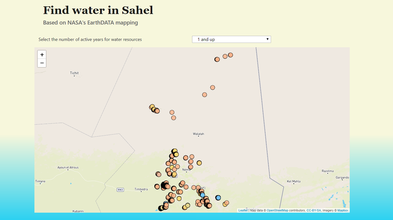
Find water in Sahel
The Sahel region experienced several historic droughts in the last century. Nomadic people living in Sahel can now find water resources in their area and select those present for 1 to 9 years in a row
Define the problem
The Sahel region is a climate zone between the African Savannah grasslands to the south and the Sahara desert to the north, across West and Central Africa.
Sahel has experienced 6 historic droughts in the last century, followed by famine. In the late 1990s, climate model studies suggested that large-scale climate changes were also triggers for the droughts.
There are 13 countries spanned across the Sahel region. Nomadic people living there (and the NGO people who assist them with modern technology required to access our website) need to know:
- WHERE are the permanent sources of water in Sahel and
- HOW reliable are those resources.
By 'reliable' we mean:
- how long these water resources can last over the years (durability) and
- how many families that water resource can support (sustainability).
Our approach
To create a website that shows water resources inside Sahel, based on EarthDATA (information collected between 2003-2011).
On our website, the users (NGO people who travel locally to help Sahel nomads) should be able to:
- search for the nearest water resource, based on their current location
- among several search results (several water resources found nearby), to select the best water resource in terms of durability (over the years).
Demo version www.helpsahel.co
- for the demo version, current location is chosen via click on the map (GPS localisation is not implemented)
- once you click on the map, the nearest water resource to you is shown, with a linear route highlighted on the map (since the terrain is mostly flat, a linear route should work for now)
Technical challenges
- to extract the data from the .NetCDF file provided by EarthDATA
- (for the demo version) to select a map areas without cities, because cities always have permanent water resources, but not everybody lives in the city (we need to target places where nomadic people live)
- how to highlight the route for a selected water resource, on the map. Google Maps does not support walking indications for the desert area
- to find ways to replace the outputs of this website in other formats that can be accessed easier by nomadic people (or the NGO people who assist them), since the Sahel region has few permanent human settlements (cities or villages)
Missing features (not implemented yet)
- for a given water resource found, show the level of proximity in terms of time (hours, minutes) and walking distance (km, metres)
- show step by step navigation for a given route
- highlight the water resources that already represent human settlements (we need to add another layer for night lights)
- in the future, our mapping should be able to filter water resources by number of families it can sustain, given a minimal daily water consumption of x litres, where x is a value between 20 and 50 litres per day. According to UN, a human being needs 50 litres of water per day (for meals and personal hygiene, in order to avoid diseases). However, many humans in Africa must get along with 20 litres of water per day.
Data source & Code repository
- https://search.earthdata.nasa.gov/search/granules?...
- https://github.com/david-batranu/nasa2018
- https://github.com/sandriu/nasa2018
Bibliography

SpaceApps is a NASA incubator innovation program.