


Torch | Spot That Fire!
The Challenge | Spot That Fire!
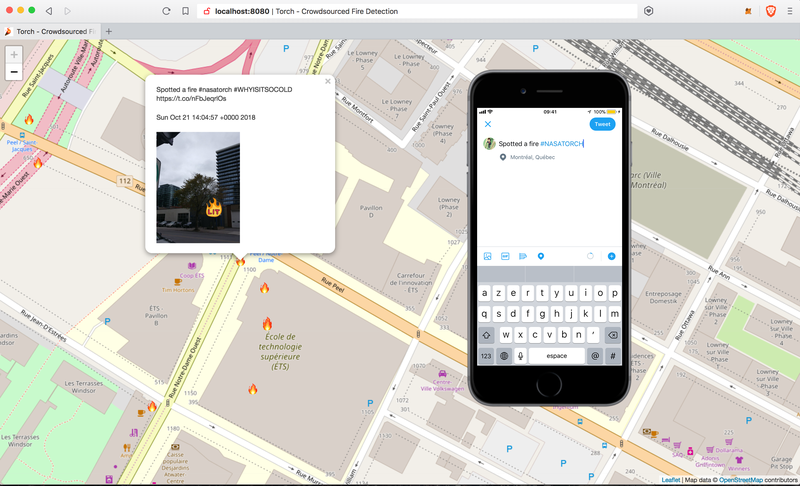
Torch
Torch is a crowdsourcing tool that uses tweets and databases about current wildfires with #nasatorch to alert users of nearby wildfires.
PROBLEM AND SOLUTION:
The damages caused by wildfires are devastating for the environment, public infrastructures and the people affected by them. By having a tool that shows on a map where a wildfire has been reported, users that are the most affected can be notified when a fire is detected nearby.
WHO IS THE USER
Everyone with internet access can use the web app to visualize the location of wildfires but Twitter users will be the main contributors to the project. People that activate their precise location when they detect a fire and send a tweet with the hashtag #nasatorch will contribute to the early-detection of wildfires. Nasa's databases with the location of the wildfires will also be added to the map and will be used to alert subscribed users of the wildfire if they are nearby.
HOW IS YOUR APPLICATION DIFFERENT THAN OTHER EXISTING ONES?
Our tool uses Twitter to track wildfires in real time. Today social media play a growing more important role in our lives. We, especially the current generation, spend a big part of our day on it. Twitter, a really popular social media and is one of the more serious ones, in the sense that it is used to post updates and information on whats happening in the world, and also is used by many powerful people and politicians as well. Thus, we thought that it would be the perfect input to allow everyday users and citizens to report fires.
Use Deep learning to train an Ai find relationship with heat maps data from radsat and the active fire available data and weather patterns + user inputs to understand/predict which areas are,most as risk of fire.
HOW WILL THIS TOOL BE USED BY THE USERS?
We have designed a prototype of a single page web app that displays a map with fire icons on the precise locations of the tweets. This information will also be used in parallel with the heat maps data from NASA and the real time location of the wildfire will be accessible through our webpage. For users subscribed to our alert service, a text message will send from our twilio number if they are close to a wildfire.
Link to our project:
https://github.com/imabhijit/TorchNASA2018/tree/le...
Resources:
Map API: https://leafletjs.com/reference-1.3.4.html
Twilio alerts with node.js: https://www.twilio.com/blog/2017/12/send-bulk-sms-...
Twitter API: https://developer.twitter.com/en/docs.html

SpaceApps is a NASA incubator innovation program.