


Thinkers of Tomorrow corporation | Spot That Fire!
The Challenge | Spot That Fire!
Intelligent Fire Detection System (I.F.D.S)
The project aims is to detect and track fires in a much faster way in areas of risk. The user can to send fire alerts as well as photos. The objective is to integrate the project with an existing IOT system in use with public lighting
The project aims is to detect and track fires in a much faster way in areas of risk. The user can to send fire alerts as well as photos. The objective is to integrate the project with an existing IOT system in use with public lighting.
Intelligent Fire Detection System (I.F.D.S)
Detects fires, both by satellites as well as sensors spread over land to facilitate the use of the app.
Motivation:
To help people get alerts of potential dangers who need this tool in order to prevent such incidents (fires) close to their homes, properties or even on the way to work.
Our project consists of presenting ways to stop loss of lives, animals and deforestation caused by fire. The goal is to give people access to information via the application.
Every year many people die from wild fires (whether caused by human action or not). So we decided to develop "I.F.D.S" a system of sensors and artificial intelligence that in addition has an app that can be monitored by anyone who has a smartphone.
The Solution:
Summary
The system we have developed during the SpaceApps weekend consists of two parts:
I.F.D.S Box: The hardware is a network that uses a series of sensors that measure the humidity of the air, the temperature and informs the amount of carbon dioxide, the device performs the detection and crosses the data to know where the flames and smoke are coming from..
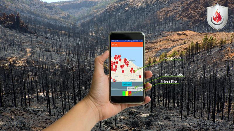
I.F.D.S App: The application uses a database available via NASA´s platform that informs us of the temperature anomalies in all regions of the planet. The application picks up all of this satellite data and plots where those fires are.
Resources used:
- CO2 Gas Sensor
- Temperature sensor
- Moisture Sensor
- Photovoltaic panel system
- 7.6v Battery
- Module gsm or LoRa module
- Atmega328
Reasoning:
To minimize the damage caused by fires, monitoring the related data and enabling immidiate intervention.
Application:
To trace the path of the wildfires ,to upload images, to prevent wild fires even after they happen, to locate fires, to rate the Fire Level, and tobe accessible to the mass Market. It shows ways of preventing fire and how to combat it.The project will be used on highways all over the world on highways that donot have regular exits, making it impossible to get out of the highway in cases of fires, for this reason the application will trace a secondary route to escape before reaching the area of potential risk, thus showing alternatives routes.

SpaceApps is a NASA incubator innovation program.