


Macprofessionals | Spot That Fire!
Awards & Nominations
Macprofessionals has received the following awards and nominations. Way to go!
The Challenge | Spot That Fire!
Inferino
Inferino is a system that collects data using an autonomous drone to predict possible wildfires in long ranges and notify nearby residents and firefighters before they spread to public areas.
Introduction
Our project offers a solution using current technology to help raise awareness about wildfires, previously known as events that would happen relatively rarely, are now breaking records by happening more often -- lasting for a longer amount of time each year. A significant increase in global warming due to climate change is making fires more vast and therefore difficult to suppress. In the past 50 years, climatic conditions that promote fire, such as fire season length, have become more common. In this situation, the need for better fire prevention and better containment has arisen.
Our project helps raise awareness about fire-hazardous events before they spread to civil areas. This product ensures fire detection in nature, which can save countless lives and prevent property damage.
What is INFERINO and how does it work?
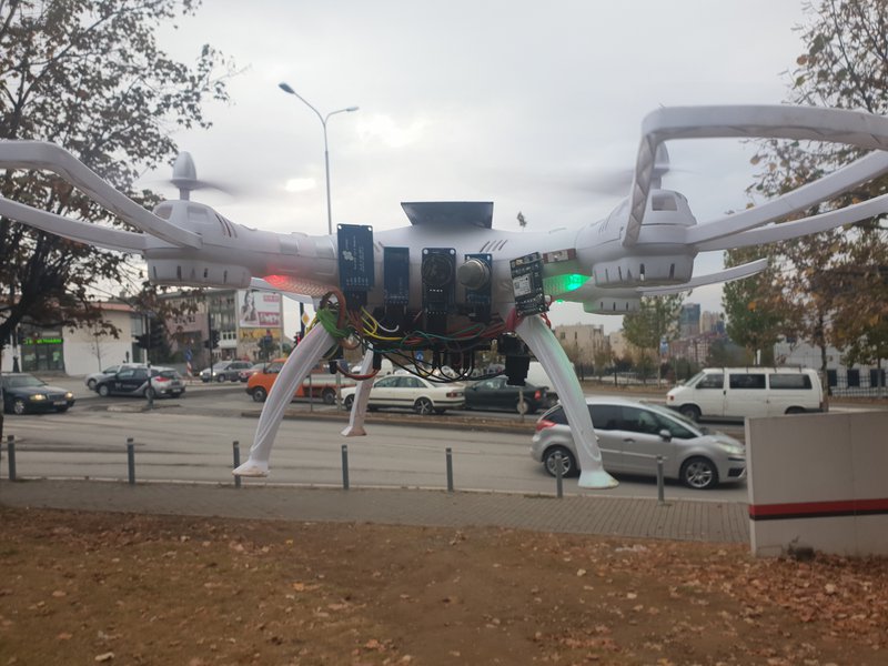
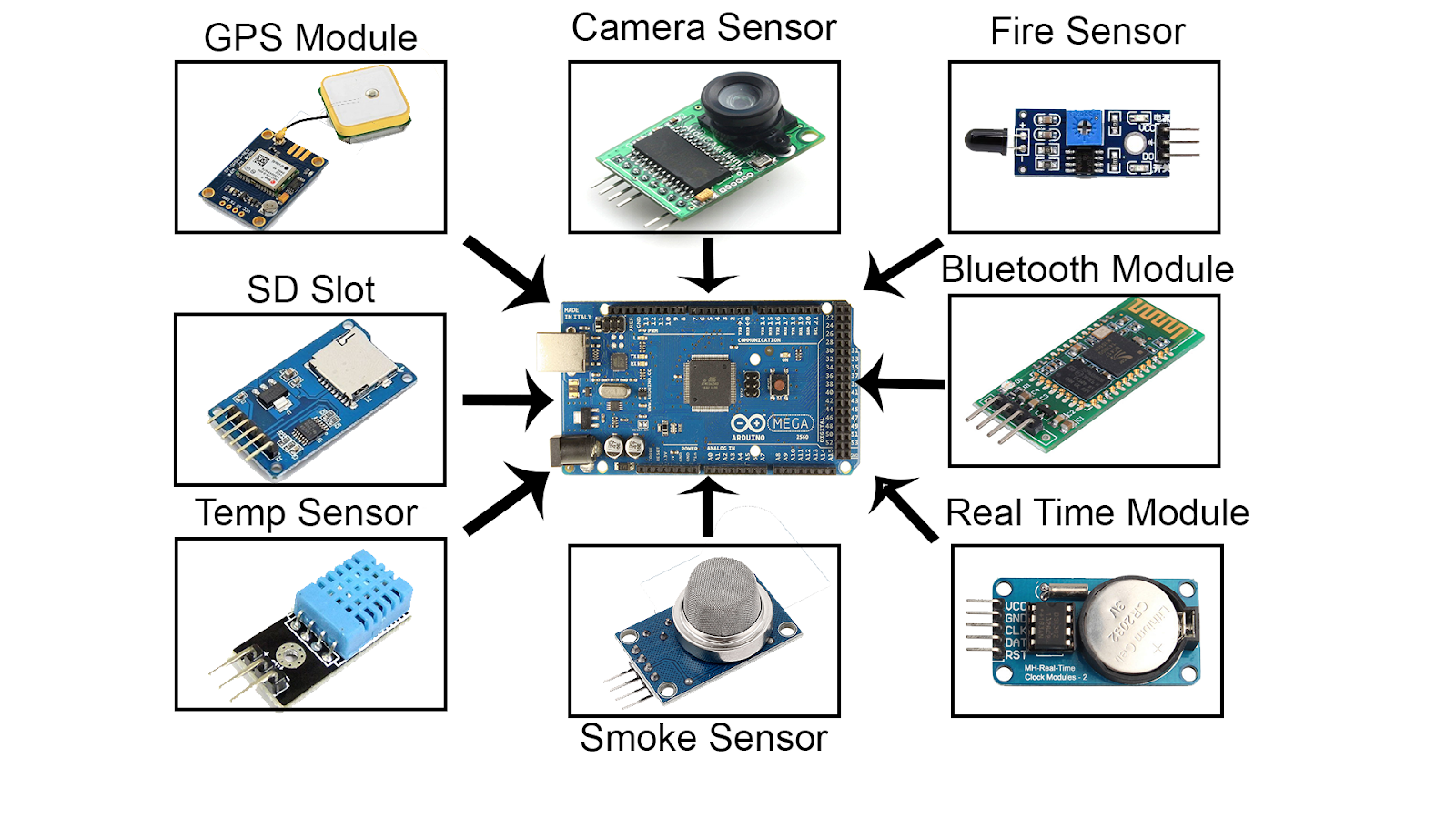
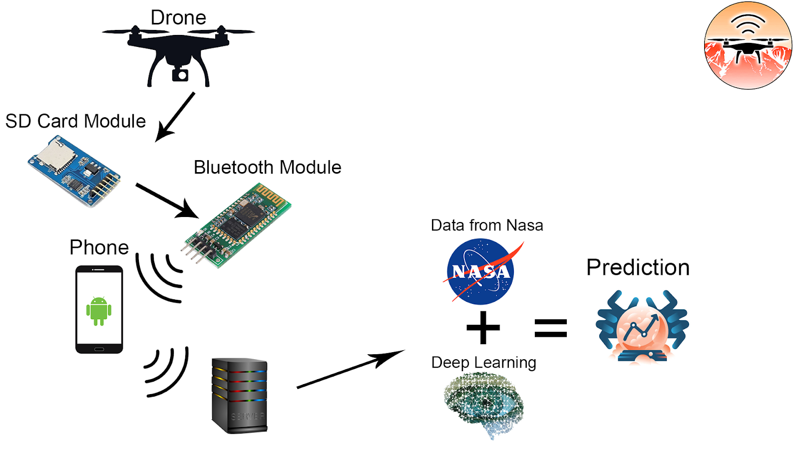
Inferino is a system which consists of a autonomous drone, administrator application, server and user application. The drone has a cluster of sensors that were made to detect heat and smoke, as well as a camera to take pictures from a high altitude (that can further be used for image processing), checking on the status of the area. It allows us to scan large regions for data regarding potential and ongoing wildfires. The drone owners (such as firefighters) can set a certain period of time (for instance, once every two or three hours) and the drone will firstly check for if the terrain is clear to launch (for example, it won't launch when there's rain or snow) and start collecting information at a regular interval, loading all of it onto an SD card and building it up into a database. Whenever the sensor finds an anomaly, it will collect significantly more input. We can also use the capability of a drone to communicate with other drones, and exchange data.
Once the drone completes its mission and returns to the base, the administrators can connect to the drone via bluetooth technology, and download the data the drone has collected. After downloading, the administrators can inspect the data or upload it directly to our servers for further analysis (you can see our administrator app screenshot here: https://drive.google.com/open?id=1IMx1bsd48iuvgt7n...).
After the scanned data is uploaded to our servers, the integrated deep-learning machine can now start analyzing the data from the scanned location, and with other past incidents that were on that particular area using the open data from NASA and NASA-affiliated organizations such as FIRMS (Fire Information Resource Management System) or INCIWEB. Or it can just analyze data from the drone (if no incident was ever recorded on that area).
When the analysis is finished, the server will update its database along with the user app, so users can view the nearby wildfire analysis. In case the probability of fire which is calculated by the data deep learning system is higher than 40%, then the app will automatically send notification to nearby residents and inform the firefighting services. Or if it has already detected fire using the flame sensor then it will send an emergency alert to all the users.
(Our user app screenshots can be seen here: https://drive.google.com/open?id=1qK3U_Vt8jGMFVpbD...)
The drone is fueled by two power sources: solar energy during the day, and a rechargeable battery during the night (which can also be used as backup power). It will be a solution that saves energy and doesn’t negatively affect the environment.
A more detailed graph can be found here: https://drive.google.com/file/d/1WxggX_dvL3jruZ73W...
Other data we can analyze from the drone
- The smoke sensor can also detect methane leaks.
- We can use image processing since our drone takes a picture every 30 seconds and stores it. With this we can analyze more than just fire! We can see how the nature is changing over the years and come with even more results.
What we used to bring the project to life
Programming- PHP (Creating the server application, data set, providing communication and more.)
- MIT App Inventor 2 (UI design and development for the administrator and user apps)
- Arduino IDE ((Native C++, C) Drone and sensor programming)
- PHPMyAdmin4 (MySQL dataset, database snapshot : https://drive.google.com/open?id=1WXWpruH0p3bj6XoY...)
Software
- Adobe Photoshop CS6 (app UI and asset design, as well as the diagrams for this page)
- Notepad++ (programming)
- Arduino IDE (programming)
- Vegas Pro 14.0 (presentation video edit)
- Adobe Premiere Pro (additional video editing)
Hardware
- An average drone
- Solar cell (battery charge when the drone is on sleep mode)
- 2x high-powered 9V battery (power source)
- Bluetooth module HC-05 (connection between the administrator application and the drone)
- MQ-2 Smoke Sensor (detection of smoke, methane leaks, butane leaks etc.)
- Flame Sensor (detects a wavelength range of 760nm - 1100nm, used for detecting signs of fire)
- GPS Module NEO-6M (to find longitude and latitude of the drone)
- DHT22 Temperature Sensor (to measure ambient temperature, humidity level and heat index)
- SD Card module (stores the data being collected from the cluster of the sensors to the SD card storage)
- Camera module (takes a picture of an area every 30 seconds, and stores it to the SD card for further image processing)
- RTC (Real-Time Clock) (keeps the time of a data record).
Conclusion
Our project is a low-cost, environmentally-friendly, user-friendly solution to one of the worst kinds of natural disasters. Our final conclusion is that this project can predict the wildfire and detect it before it even happens or if it has started as a micro one, with a low-cost, wider-range and way more effective solution.
GITHUB LINK: github.com/0dayboi/inferino
References“Wildfires are burning longer and hotter each year”, Axios, 2018.
“Climate Change: Global Temperature”, Rebecca Lindsey and LuAnn Dahlman, 2018.
https://www.climate.gov/news-features/understanding-climate/climate-change-global-temperature
“Nearly a record breaking year for acres burned in the U.S.”, Wildfire Today, 2018.
https://wildfiretoday.com/2018/01/10/nearly-a-record-breaking-year-for-acres-burned-in-the-u-s/
“Global landcover change – wildfires”, State of the World’s Plants, 2017.

SpaceApps is a NASA incubator innovation program.